QUICK READ
The project in three views.
Problem
Southern Chilean fjords and channels mix phytoplankton, CDOM and suspended sediments. This optical complexity limits the performance of global ocean-colour algorithms.
WORKFLOW
How the components fit together.
Measure
Field bio-optics and water-quality observations.
Characterise
Optical signatures of species in the laboratory.
Model
Radiative transfer and spectral scenarios.
Operationalise
Algorithms, Data Cube and platform integration.
CONTEXT
Characterising waters where satellites observe mixed signals
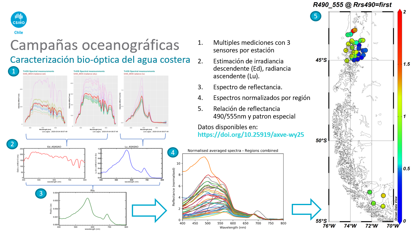
Patagonian coastal waters have complex reflectance signatures. Field work measured suspended solids, CDOM absorption, particle absorption, pigments using HPLC, spectral radiance and irradiance. These observations characterised how reflectance changes across coastal environments and which components of that variability can be confused with an algal bloom.
ANALYSIS
Building bio-optical signatures of target species
Cultures of target species were analysed for absorption, backscattering and pigment composition. The question was whether harmful-bloom species showed optical differences strong enough to improve discrimination using remote observations.
ANALYSIS
Simulating conditions that field campaigns cannot cover
In situ and laboratory observations parameterised radiative-transfer models using EcoLight. Hundreds of spectra were simulated across combinations of chlorophyll, CDOM, suspended sediment and phytoplankton species. This enabled systematic testing of signal sensitivity and comparison of nine detection algorithms. The RITakahashi index showed exploratory potential for Alexandrium-dominated events and was tested on a 2006 MODIS-Aqua scene.
ANALYSIS
Designing the path towards an operational system
The project assessed how regionally tuned satellite products could be integrated with SIMA Austral, hydrodynamic and biogeochemical models, in situ monitoring and WMS services. The proposed architecture used Open Data Cube to automate satellite products and deliver them to decision platforms. Bio-optical datasets from 2017-2020 were also published with DOI identifiers to support reuse and future validation.
Project figures
See the analysis.
PROJECT VALUE
What this project demonstrates
Ability to connect field observations, signal physics, spectral modelling, satellite algorithms and data architecture within a workflow that can progress towards operational monitoring.
Satellites provide spatial coverage, but reliable bloom detection depends on understanding local optical physics and combining it with field observations and oceanographic models.
Project developed with CSIRO · CSIRO Chile · IFOP · ANID. 2020