QUICK READ
The project in three views.
Problem
A system degraded over decades by hydrological change, infrastructure, agriculture, fire and ENSO, documented through historical sources that were not directly comparable.
WORKFLOW
How the components fit together.
Integrate
Historical cover, satellite observations and environmental variables.
Validate
Identify misalignment, methodological change and data gaps.
Reconstruct
Detect trajectories and ecological inflection points.
Prioritise
Group responses and estimate restoration potential.
CONTEXT
Reconstructing a trajectory, not just a map
Ciénaga Grande de Santa Marta is one of South America’s most important wetlands and a Ramsar site. Mangrove cover declined sharply from the mid-twentieth century alongside modification of the estuarine system, agricultural expansion, roads, altered freshwater inputs and other cumulative pressures. Restoration interventions initiated in the 1990s recovered part of the lost cover, but the response was spatially heterogeneous.
ANALYSIS
A common structure for incompatible evidence
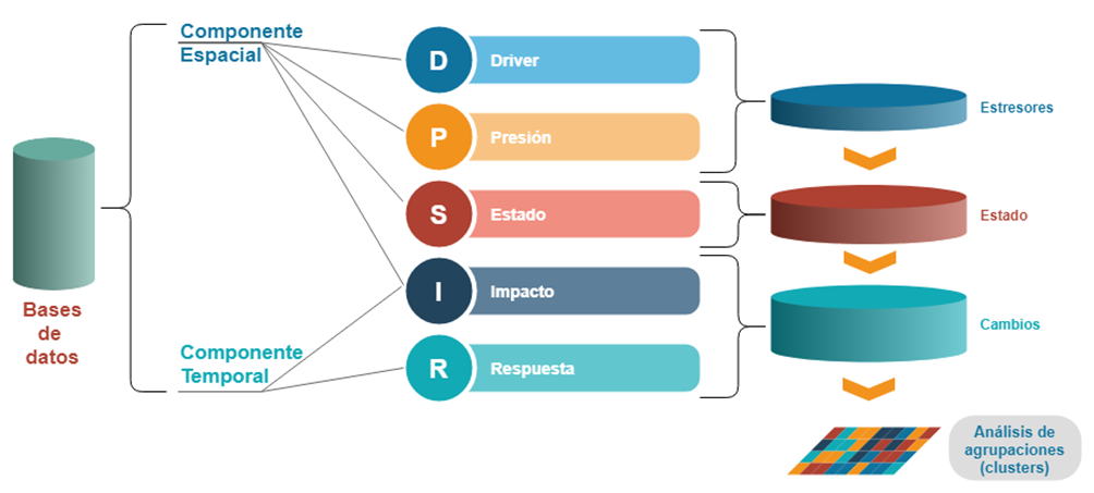
The analysis used the DPSIR framework to link drivers, pressures, ecosystem state, impacts and responses. The spatial chronology combined historical mangrove maps from 1956 with more recent Landsat, SPOT, ASTER, RapidEye, Sentinel-2 and PlanetScope products. Several pre-2001 layers were misaligned by more than 300 m and used different mapping criteria. Rather than treating them as equivalent measurements, they were retained as approximate evidence of historical extent and potentially recoverable areas.
ANALYSIS
Time series to detect inflection points
The temporal dimension was strengthened with Landsat time series processed in EASI, an Open Data Cube platform deployed on AWS. The 1985-2020 archive was used to assess changes in NDVI and its variability around key inflection points. Recovery after 2007, losses during 2014-2015 and recovery after 2017 could be compared with fire, ENSO, flooding and restoration interventions.
ANALYSIS
From environmental history to prioritisation
NASA FIRMS fire observations, surface-water dynamics, agriculture, infrastructure, geomorphology, precipitation, elevation and ecosystem data were integrated to characterise areas with different combinations of stress and response. The resulting clusters summarised distinct ecological trajectories and provided the basis for a restoration-potential map. The preliminary analysis identified about 13,100 ha with higher recovery potential, subject to important information gaps in salinity, high-accuracy elevation, bathymetry and hydrological and social feasibility.
Project figures
See the analysis.
PROJECT VALUE
What this project demonstrates
Ability to integrate historical archives, satellite time series, environmental evidence and quality controls into a spatial reconstruction useful for restoration and prioritisation.
Restoration decisions change when we know not only where mangroves once occurred, but how each area historically responded to drought, flooding, fire and intervention.
Project developed with INVEMAR · CSIRO Chile · CSIRO. 2022